|
|
|||||||||||||||||
| Point ID: 7474 | Downloads | Plots | Site Data | Code: 70396 |
|
|
|||||||||||||||||
| Download | |
|---|---|
| Site Descriptor Information | Site Time Series Data |
| Link to all available data | |
| View: | Time Series | All |
| Units: | mm |
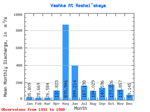
| Statistic | Jan | Feb | Mar | Apr | May | Jun | Jul | Aug | Sep | Oct | Nov | Dec | Annual |
|---|---|---|---|---|---|---|---|---|---|---|---|---|---|
| Mean | 35.81 | 28.67 | 26.58 | 110.82 | 870.95 | 399.21 | 167.20 | 104.03 | 140.60 | 177.23 | 119.86 | 59.15 | 186.39 |
| Standard Deviation | 10.10 | 8.06 | 5.86 | 156.27 | 275.06 | 222.40 | 89.87 | 85.62 | 102.84 | 96.27 | 63.52 | 22.57 | 34.64 |
| Min | 14.90 | 9.39 | 13.00 | 19.90 | 302.00 | 109.00 | 42.50 | 25.40 | 23.10 | 17.70 | 17.90 | 17.40 | 91.94 |
| Max | 59.80 | 50.20 | 38.50 | 789.00 | 1410.00 | 1100.00 | 415.00 | 519.00 | 682.00 | 496.00 | 346.00 | 122.00 | 265.16 |
| Coefficient of Variation | 0.28 | 0.28 | 0.22 | 1.41 | 0.32 | 0.56 | 0.54 | 0.82 | 0.73 | 0.54 | 0.53 | 0.38 | 0.19 |
 Return to R-Arctic Net Home Page