|
|
|||||||||||||||||
| Point ID: 7463 | Downloads | Plots | Site Data | Code: 70372 |
|
|
|||||||||||||||||
| Download | |
|---|---|
| Site Descriptor Information | Site Time Series Data |
| Link to all available data | |
| View: | Time Series | All |
| Units: | m3/s |
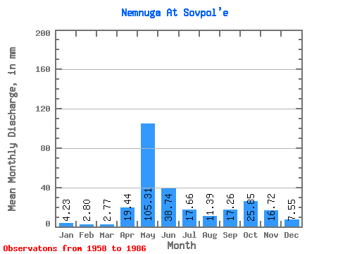
| Statistic | Jan | Feb | Mar | Apr | May | Jun | Jul | Aug | Sep | Oct | Nov | Dec | Annual |
|---|---|---|---|---|---|---|---|---|---|---|---|---|---|
| Mean | 4.23 | 2.83 | 2.77 | 19.44 | 105.29 | 38.74 | 17.66 | 11.39 | 17.26 | 25.84 | 16.72 | 7.55 | 268.69 |
| Standard Deviation | 1.21 | 0.61 | 0.55 | 27.83 | 30.44 | 21.80 | 10.90 | 6.80 | 9.42 | 14.01 | 9.51 | 3.63 | 41.89 |
| Min | 2.62 | 1.77 | 1.66 | 1.78 | 32.55 | 10.98 | 6.94 | 4.46 | 4.81 | 5.62 | 2.93 | 2.73 | 185.25 |
| Max | 7.45 | 4.13 | 3.86 | 111.60 | 163.66 | 90.90 | 54.68 | 29.11 | 37.08 | 64.62 | 38.25 | 18.88 | 336.75 |
| Coefficient of Variation | 0.29 | 0.22 | 0.20 | 1.43 | 0.29 | 0.56 | 0.62 | 0.60 | 0.55 | 0.54 | 0.57 | 0.48 | 0.16 |
 Return to R-Arctic Net Home Page