|
|
|||||||||||||||||
| Point ID: 7463 | Downloads | Plots | Site Data | Code: 70372 |
|
|
|||||||||||||||||
| Download | |
|---|---|
| Site Descriptor Information | Site Time Series Data |
| Link to all available data | |
| View: | Time Series | All |
| Units: | mm |
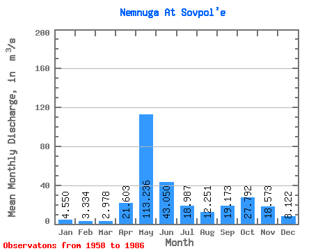
| Statistic | Jan | Feb | Mar | Apr | May | Jun | Jul | Aug | Sep | Oct | Nov | Dec | Annual |
|---|---|---|---|---|---|---|---|---|---|---|---|---|---|
| Mean | 4.55 | 3.33 | 2.98 | 21.60 | 113.24 | 43.05 | 18.99 | 12.25 | 19.17 | 27.79 | 18.57 | 8.12 | 24.52 |
| Standard Deviation | 1.30 | 0.73 | 0.60 | 30.92 | 32.73 | 24.22 | 11.72 | 7.32 | 10.47 | 15.07 | 10.57 | 3.91 | 3.82 |
| Min | 2.82 | 2.09 | 1.79 | 1.98 | 35.00 | 12.20 | 7.46 | 4.80 | 5.34 | 6.04 | 3.26 | 2.94 | 16.91 |
| Max | 8.01 | 4.88 | 4.15 | 124.00 | 176.00 | 101.00 | 58.80 | 31.30 | 41.20 | 69.50 | 42.50 | 20.30 | 30.73 |
| Coefficient of Variation | 0.29 | 0.22 | 0.20 | 1.43 | 0.29 | 0.56 | 0.62 | 0.60 | 0.55 | 0.54 | 0.57 | 0.48 | 0.16 |
 Return to R-Arctic Net Home Page