|
|
|||||||||||||||||
| Point ID: 7444 | Downloads | Plots | Site Data | Code: 70339 |
|
|
|||||||||||||||||
| Download | |
|---|---|
| Site Descriptor Information | Site Time Series Data |
| Link to all available data | |
| View: | Time Series | All |
| Units: | m3/s |
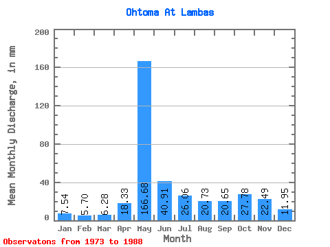
| Statistic | Jan | Feb | Mar | Apr | May | Jun | Jul | Aug | Sep | Oct | Nov | Dec | Annual |
|---|---|---|---|---|---|---|---|---|---|---|---|---|---|
| Mean | 7.54 | 5.75 | 6.27 | 18.33 | 166.65 | 40.91 | 26.05 | 20.72 | 20.65 | 27.78 | 22.49 | 11.95 | 374.18 |
| Standard Deviation | 1.76 | 1.24 | 0.73 | 16.96 | 43.49 | 21.96 | 17.85 | 19.00 | 10.22 | 11.78 | 14.46 | 6.57 | 47.74 |
| Min | 5.38 | 3.67 | 4.98 | 6.04 | 72.83 | 12.52 | 8.28 | 6.65 | 7.79 | 8.50 | 6.87 | 5.88 | 269.62 |
| Max | 11.04 | 8.45 | 7.46 | 70.93 | 247.90 | 84.50 | 69.21 | 77.81 | 40.37 | 43.29 | 55.60 | 33.38 | 456.07 |
| Coefficient of Variation | 0.23 | 0.22 | 0.12 | 0.93 | 0.26 | 0.54 | 0.69 | 0.92 | 0.49 | 0.42 | 0.64 | 0.55 | 0.13 |
 Return to R-Arctic Net Home Page