|
|
|||||||||||||||||
| Point ID: 7444 | Downloads | Plots | Site Data | Code: 70339 |
|
|
|||||||||||||||||
| Download | |
|---|---|
| Site Descriptor Information | Site Time Series Data |
| Link to all available data | |
| View: | Time Series | All |
| Units: | mm |
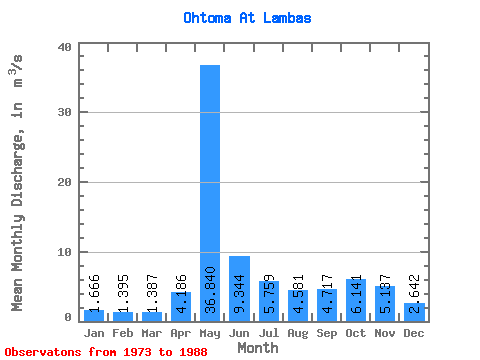
| Statistic | Jan | Feb | Mar | Apr | May | Jun | Jul | Aug | Sep | Oct | Nov | Dec | Annual |
|---|---|---|---|---|---|---|---|---|---|---|---|---|---|
| Mean | 1.67 | 1.40 | 1.39 | 4.19 | 36.84 | 9.34 | 5.76 | 4.58 | 4.72 | 6.14 | 5.14 | 2.64 | 7.02 |
| Standard Deviation | 0.39 | 0.30 | 0.16 | 3.87 | 9.62 | 5.02 | 3.95 | 4.20 | 2.33 | 2.60 | 3.30 | 1.45 | 0.90 |
| Min | 1.19 | 0.89 | 1.10 | 1.38 | 16.10 | 2.86 | 1.83 | 1.47 | 1.78 | 1.88 | 1.57 | 1.30 | 5.06 |
| Max | 2.44 | 2.05 | 1.65 | 16.20 | 54.80 | 19.30 | 15.30 | 17.20 | 9.22 | 9.57 | 12.70 | 7.38 | 8.55 |
| Coefficient of Variation | 0.23 | 0.22 | 0.12 | 0.93 | 0.26 | 0.54 | 0.69 | 0.92 | 0.49 | 0.42 | 0.64 | 0.55 | 0.13 |
 Return to R-Arctic Net Home Page