|
|
|||||||||||||||||
| Point ID: 7431 | Downloads | Plots | Site Data | Code: 70299 |
|
|
|||||||||||||||||
| Download | |
|---|---|
| Site Descriptor Information | Site Time Series Data |
| Link to all available data | |
| View: | Time Series | All |
| Units: | m3/s |
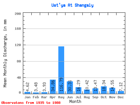
| Statistic | Jan | Feb | Mar | Apr | May | Jun | Jul | Aug | Sep | Oct | Nov | Dec | Annual |
|---|---|---|---|---|---|---|---|---|---|---|---|---|---|
| Mean | 4.62 | 3.51 | 3.93 | 34.86 | 116.77 | 30.31 | 16.28 | 10.42 | 13.47 | 18.34 | 14.55 | 7.12 | 272.65 |
| Standard Deviation | 1.37 | 0.74 | 0.72 | 30.53 | 50.19 | 15.88 | 11.81 | 12.14 | 14.95 | 12.89 | 9.97 | 3.74 | 67.26 |
| Min | 2.26 | 1.82 | 1.40 | 3.14 | 28.90 | 5.86 | 3.47 | 2.86 | 3.44 | 2.78 | 2.65 | 2.28 | 145.77 |
| Max | 8.62 | 5.14 | 6.77 | 126.54 | 217.43 | 78.85 | 52.57 | 86.70 | 91.11 | 67.16 | 54.34 | 23.12 | 482.43 |
| Coefficient of Variation | 0.30 | 0.21 | 0.18 | 0.88 | 0.43 | 0.52 | 0.73 | 1.17 | 1.11 | 0.70 | 0.69 | 0.53 | 0.25 |
 Return to R-Arctic Net Home Page