|
|
|||||||||||||||||
| Point ID: 7431 | Downloads | Plots | Site Data | Code: 70299 |
|
|
|||||||||||||||||
| Download | |
|---|---|
| Site Descriptor Information | Site Time Series Data |
| Link to all available data | |
| View: | Time Series | All |
| Units: | mm |
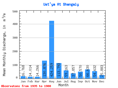
| Statistic | Jan | Feb | Mar | Apr | May | Jun | Jul | Aug | Sep | Oct | Nov | Dec | Annual |
|---|---|---|---|---|---|---|---|---|---|---|---|---|---|
| Mean | 16.77 | 14.01 | 14.27 | 130.88 | 424.26 | 113.79 | 59.16 | 37.86 | 50.57 | 66.63 | 54.63 | 25.88 | 84.06 |
| Standard Deviation | 4.98 | 2.94 | 2.63 | 114.61 | 182.35 | 59.63 | 42.92 | 44.12 | 56.12 | 46.85 | 37.43 | 13.58 | 20.74 |
| Min | 8.20 | 7.27 | 5.09 | 11.80 | 105.00 | 22.00 | 12.60 | 10.40 | 12.90 | 10.10 | 9.95 | 8.28 | 44.94 |
| Max | 31.30 | 20.50 | 24.60 | 475.00 | 790.00 | 296.00 | 191.00 | 315.00 | 342.00 | 244.00 | 204.00 | 84.00 | 148.73 |
| Coefficient of Variation | 0.30 | 0.21 | 0.18 | 0.88 | 0.43 | 0.52 | 0.73 | 1.17 | 1.11 | 0.70 | 0.69 | 0.53 | 0.25 |
 Return to R-Arctic Net Home Page