|
|
|||||||||||||||||
| Point ID: 7427 | Downloads | Plots | Site Data | Code: 70293 |
|
|
|||||||||||||||||
| Download | |
|---|---|
| Site Descriptor Information | Site Time Series Data |
| Link to all available data | |
| View: | Time Series | All |
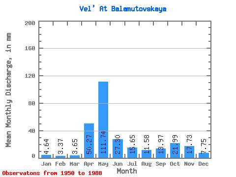
| Units: | m3/s |
| Statistic | Jan | Feb | Mar | Apr | May | Jun | Jul | Aug | Sep | Oct | Nov | Dec | Annual |
|---|---|---|---|---|---|---|---|---|---|---|---|---|---|
| Mean | 4.64 | 3.40 | 3.65 | 50.27 | 111.72 | 27.30 | 15.65 | 11.58 | 13.97 | 21.98 | 17.73 | 7.75 | 289.88 |
| Standard Deviation | 1.46 | 0.91 | 0.70 | 37.57 | 54.80 | 17.41 | 11.22 | 10.38 | 11.72 | 14.36 | 13.52 | 4.55 | 68.27 |
| Min | 2.60 | 1.90 | 2.50 | 6.11 | 25.95 | 6.27 | 3.63 | 2.57 | 3.59 | 4.46 | 2.79 | 2.30 | 188.91 |
| Max | 9.46 | 5.70 | 5.53 | 158.52 | 242.35 | 79.80 | 46.64 | 45.76 | 51.52 | 58.10 | 59.98 | 25.89 | 447.85 |
| Coefficient of Variation | 0.31 | 0.27 | 0.19 | 0.75 | 0.49 | 0.64 | 0.72 | 0.90 | 0.84 | 0.65 | 0.76 | 0.59 | 0.24 |
 Return to R-Arctic Net Home Page