|
|
|||||||||||||||||
| Point ID: 7427 | Downloads | Plots | Site Data | Code: 70293 |
|
|
|||||||||||||||||
| Download | |
|---|---|
| Site Descriptor Information | Site Time Series Data |
| Link to all available data | |
| View: | Time Series | All |
| Units: | mm |
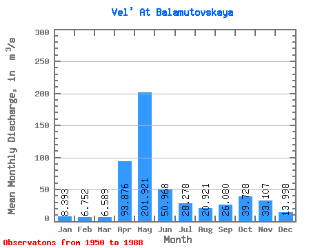
| Statistic | Jan | Feb | Mar | Apr | May | Jun | Jul | Aug | Sep | Oct | Nov | Dec | Annual |
|---|---|---|---|---|---|---|---|---|---|---|---|---|---|
| Mean | 8.39 | 6.75 | 6.59 | 93.88 | 201.92 | 50.97 | 28.28 | 20.92 | 26.08 | 39.73 | 33.11 | 14.00 | 44.46 |
| Standard Deviation | 2.63 | 1.81 | 1.27 | 70.16 | 99.04 | 32.50 | 20.27 | 18.75 | 21.88 | 25.95 | 25.24 | 8.22 | 10.47 |
| Min | 4.70 | 3.76 | 4.52 | 11.40 | 46.90 | 11.70 | 6.56 | 4.65 | 6.70 | 8.06 | 5.21 | 4.15 | 28.97 |
| Max | 17.10 | 11.30 | 9.99 | 296.00 | 438.00 | 149.00 | 84.30 | 82.70 | 96.20 | 105.00 | 112.00 | 46.80 | 68.68 |
| Coefficient of Variation | 0.31 | 0.27 | 0.19 | 0.75 | 0.49 | 0.64 | 0.72 | 0.90 | 0.84 | 0.65 | 0.76 | 0.59 | 0.24 |
 Return to R-Arctic Net Home Page