|
|
|||||||||||||||||
| Point ID: 742 | Downloads | Plots | Site Data | Code: 07GA001 |
|
|
|||||||||||||||||
| Download | |
|---|---|
| Site Descriptor Information | Site Time Series Data |
| Link to all available data | |
| View: | Time Series | All |
| Units: | m3/s |
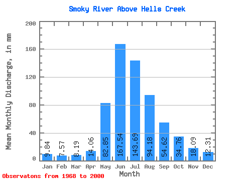
| Statistic | Jan | Feb | Mar | Apr | May | Jun | Jul | Aug | Sep | Oct | Nov | Dec | Annual |
|---|---|---|---|---|---|---|---|---|---|---|---|---|---|
| Mean | 9.84 | 7.63 | 8.19 | 14.06 | 82.84 | 167.54 | 143.66 | 94.17 | 54.62 | 34.76 | 18.09 | 12.31 | 647.92 |
| Standard Deviation | 2.08 | 0.94 | 1.34 | 5.00 | 24.49 | 43.91 | 33.39 | 20.68 | 12.59 | 9.73 | 4.19 | 3.60 | 75.71 |
| Min | 6.97 | 5.93 | 6.33 | 8.64 | 34.59 | 91.12 | 78.81 | 69.67 | 34.09 | 19.88 | 10.06 | 7.04 | 518.19 |
| Max | 16.88 | 9.53 | 13.04 | 25.38 | 117.16 | 298.35 | 210.61 | 138.78 | 86.40 | 57.67 | 25.04 | 22.04 | 812.40 |
| Coefficient of Variation | 0.21 | 0.12 | 0.16 | 0.35 | 0.30 | 0.26 | 0.23 | 0.22 | 0.23 | 0.28 | 0.23 | 0.29 | 0.12 |
 Return to R-Arctic Net Home Page