|
|
|||||||||||||||||
| Point ID: 742 | Downloads | Plots | Site Data | Code: 07GA001 |
|
|
|||||||||||||||||
| Download | |
|---|---|
| Site Descriptor Information | Site Time Series Data |
| Link to all available data | |
| View: | Time Series | All |
| Units: | mm |
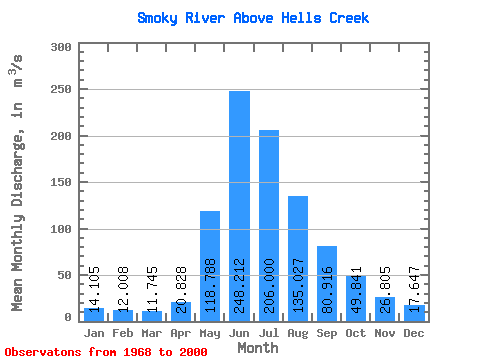
| Statistic | Jan | Feb | Mar | Apr | May | Jun | Jul | Aug | Sep | Oct | Nov | Dec | Annual |
|---|---|---|---|---|---|---|---|---|---|---|---|---|---|
| Mean | 14.11 | 12.01 | 11.74 | 20.83 | 118.79 | 248.21 | 206.00 | 135.03 | 80.92 | 49.84 | 26.80 | 17.65 | 78.83 |
| Standard Deviation | 2.99 | 1.47 | 1.92 | 7.40 | 35.11 | 65.06 | 47.88 | 29.65 | 18.65 | 13.95 | 6.21 | 5.17 | 9.21 |
| Min | 10.00 | 9.33 | 9.07 | 12.80 | 49.60 | 135.00 | 113.00 | 99.90 | 50.50 | 28.50 | 14.90 | 10.10 | 63.05 |
| Max | 24.20 | 15.00 | 18.70 | 37.60 | 168.00 | 442.00 | 302.00 | 199.00 | 128.00 | 82.70 | 37.10 | 31.60 | 98.85 |
| Coefficient of Variation | 0.21 | 0.12 | 0.16 | 0.35 | 0.30 | 0.26 | 0.23 | 0.22 | 0.23 | 0.28 | 0.23 | 0.29 | 0.12 |
 Return to R-Arctic Net Home Page