|
|
|||||||||||||||||
| Point ID: 7419 | Downloads | Plots | Site Data | Code: 70271 |
|
|
|||||||||||||||||
| Download | |
|---|---|
| Site Descriptor Information | Site Time Series Data |
| Link to all available data | |
| View: | Time Series | All |
| Units: | m3/s |
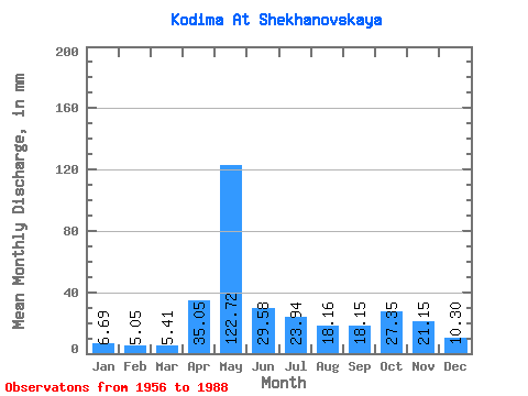
| Statistic | Jan | Feb | Mar | Apr | May | Jun | Jul | Aug | Sep | Oct | Nov | Dec | Annual |
|---|---|---|---|---|---|---|---|---|---|---|---|---|---|
| Mean | 6.69 | 5.09 | 5.41 | 35.05 | 122.70 | 29.58 | 23.93 | 18.16 | 18.15 | 27.34 | 21.16 | 10.30 | 321.62 |
| Standard Deviation | 1.75 | 1.24 | 1.14 | 33.92 | 49.44 | 15.20 | 16.80 | 14.45 | 8.55 | 12.36 | 13.32 | 4.98 | 67.34 |
| Min | 3.96 | 2.94 | 3.41 | 6.24 | 33.22 | 7.93 | 6.07 | 5.34 | 6.59 | 9.94 | 6.32 | 4.79 | 186.54 |
| Max | 12.52 | 7.88 | 9.02 | 140.73 | 224.55 | 63.15 | 58.71 | 62.12 | 39.37 | 55.68 | 55.14 | 27.61 | 431.37 |
| Coefficient of Variation | 0.26 | 0.24 | 0.21 | 0.97 | 0.40 | 0.51 | 0.70 | 0.80 | 0.47 | 0.45 | 0.63 | 0.48 | 0.21 |
 Return to R-Arctic Net Home Page