|
|
|||||||||||||||||
| Point ID: 7419 | Downloads | Plots | Site Data | Code: 70271 |
|
|
|||||||||||||||||
| Download | |
|---|---|
| Site Descriptor Information | Site Time Series Data |
| Link to all available data | |
| View: | Time Series | All |
| Units: | mm |
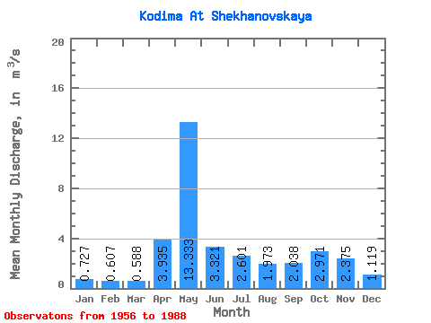
| Statistic | Jan | Feb | Mar | Apr | May | Jun | Jul | Aug | Sep | Oct | Nov | Dec | Annual |
|---|---|---|---|---|---|---|---|---|---|---|---|---|---|
| Mean | 0.73 | 0.61 | 0.59 | 3.94 | 13.33 | 3.32 | 2.60 | 1.97 | 2.04 | 2.97 | 2.38 | 1.12 | 2.97 |
| Standard Deviation | 0.19 | 0.15 | 0.12 | 3.81 | 5.37 | 1.71 | 1.83 | 1.57 | 0.96 | 1.34 | 1.50 | 0.54 | 0.62 |
| Min | 0.43 | 0.35 | 0.37 | 0.70 | 3.61 | 0.89 | 0.66 | 0.58 | 0.74 | 1.08 | 0.71 | 0.52 | 1.72 |
| Max | 1.36 | 0.94 | 0.98 | 15.80 | 24.40 | 7.09 | 6.38 | 6.75 | 4.42 | 6.05 | 6.19 | 3.00 | 3.98 |
| Coefficient of Variation | 0.26 | 0.24 | 0.21 | 0.97 | 0.40 | 0.51 | 0.70 | 0.80 | 0.47 | 0.45 | 0.63 | 0.48 | 0.21 |
 Return to R-Arctic Net Home Page