|
|
|||||||||||||||||
| Point ID: 7413 | Downloads | Plots | Site Data | Code: 70252 |
|
|
|||||||||||||||||
| Download | |
|---|---|
| Site Descriptor Information | Site Time Series Data |
| Link to all available data | |
| View: | Time Series | All |
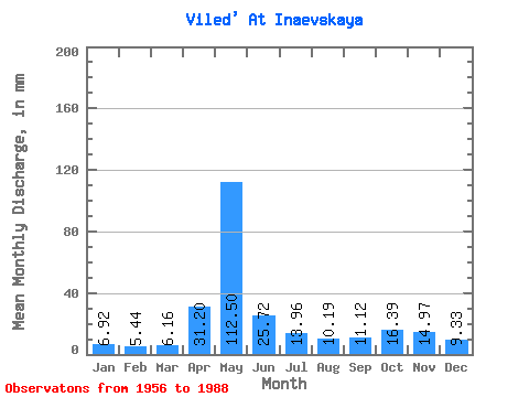
| Units: | m3/s |
| Statistic | Jan | Feb | Mar | Apr | May | Jun | Jul | Aug | Sep | Oct | Nov | Dec | Annual |
|---|---|---|---|---|---|---|---|---|---|---|---|---|---|
| Mean | 6.92 | 5.48 | 6.16 | 31.20 | 112.48 | 25.72 | 13.96 | 10.19 | 11.12 | 16.39 | 14.97 | 9.33 | 262.39 |
| Standard Deviation | 2.61 | 1.48 | 1.57 | 22.71 | 44.03 | 11.01 | 6.01 | 4.20 | 5.11 | 7.18 | 7.57 | 4.91 | 46.86 |
| Min | 3.99 | 3.70 | 4.54 | 5.45 | 23.94 | 8.36 | 6.17 | 5.58 | 5.30 | 7.67 | 3.65 | 5.16 | 135.05 |
| Max | 17.71 | 11.83 | 12.93 | 82.07 | 188.37 | 56.10 | 31.77 | 24.36 | 31.17 | 31.66 | 36.26 | 26.89 | 339.42 |
| Coefficient of Variation | 0.38 | 0.27 | 0.26 | 0.73 | 0.39 | 0.43 | 0.43 | 0.41 | 0.46 | 0.44 | 0.51 | 0.53 | 0.18 |
 Return to R-Arctic Net Home Page