|
|
|||||||||||||||||
| Point ID: 7413 | Downloads | Plots | Site Data | Code: 70252 |
|
|
|||||||||||||||||
| Download | |
|---|---|
| Site Descriptor Information | Site Time Series Data |
| Link to all available data | |
| View: | Time Series | All |
| Units: | mm |
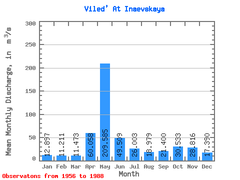
| Statistic | Jan | Feb | Mar | Apr | May | Jun | Jul | Aug | Sep | Oct | Nov | Dec | Annual |
|---|---|---|---|---|---|---|---|---|---|---|---|---|---|
| Mean | 12.90 | 11.21 | 11.47 | 60.06 | 209.59 | 49.51 | 26.00 | 18.98 | 21.40 | 30.53 | 28.82 | 17.39 | 41.49 |
| Standard Deviation | 4.87 | 3.04 | 2.92 | 43.73 | 82.05 | 21.19 | 11.19 | 7.82 | 9.84 | 13.39 | 14.57 | 9.14 | 7.41 |
| Min | 7.43 | 7.57 | 8.46 | 10.50 | 44.60 | 16.10 | 11.50 | 10.40 | 10.20 | 14.30 | 7.02 | 9.62 | 21.35 |
| Max | 33.00 | 24.20 | 24.10 | 158.00 | 351.00 | 108.00 | 59.20 | 45.40 | 60.00 | 59.00 | 69.80 | 50.10 | 53.67 |
| Coefficient of Variation | 0.38 | 0.27 | 0.26 | 0.73 | 0.39 | 0.43 | 0.43 | 0.41 | 0.46 | 0.44 | 0.51 | 0.53 | 0.18 |
 Return to R-Arctic Net Home Page