|
|
|||||||||||||||||
| Point ID: 7401 | Downloads | Plots | Site Data | Code: 70227 |
|
|
|||||||||||||||||
| Download | |
|---|---|
| Site Descriptor Information | Site Time Series Data |
| Link to all available data | |
| View: | Time Series | All |
| Units: | m3/s |
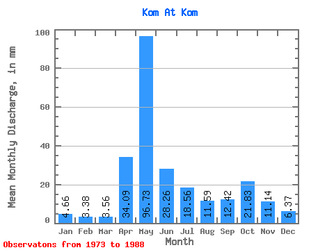
| Statistic | Jan | Feb | Mar | Apr | May | Jun | Jul | Aug | Sep | Oct | Nov | Dec | Annual |
|---|---|---|---|---|---|---|---|---|---|---|---|---|---|
| Mean | 4.66 | 3.41 | 3.56 | 34.10 | 96.71 | 28.26 | 18.56 | 11.59 | 12.42 | 21.83 | 11.14 | 6.37 | 250.57 |
| Standard Deviation | 2.43 | 1.88 | 1.28 | 28.63 | 50.54 | 19.20 | 11.66 | 7.48 | 7.49 | 13.29 | 7.03 | 2.52 | 53.55 |
| Min | 1.42 | 1.15 | 1.66 | 2.37 | 17.14 | 13.00 | 2.77 | 3.24 | 3.75 | 4.74 | 2.45 | 2.05 | 141.12 |
| Max | 10.82 | 7.41 | 6.16 | 89.46 | 199.07 | 84.11 | 42.42 | 24.25 | 26.84 | 44.63 | 30.89 | 11.61 | 314.59 |
| Coefficient of Variation | 0.52 | 0.55 | 0.36 | 0.84 | 0.52 | 0.68 | 0.63 | 0.65 | 0.60 | 0.61 | 0.63 | 0.40 | 0.21 |
 Return to R-Arctic Net Home Page