|
|
|||||||||||||||||
| Point ID: 7401 | Downloads | Plots | Site Data | Code: 70227 |
|
|
|||||||||||||||||
| Download | |
|---|---|
| Site Descriptor Information | Site Time Series Data |
| Link to all available data | |
| View: | Time Series | All |
| Units: | mm |
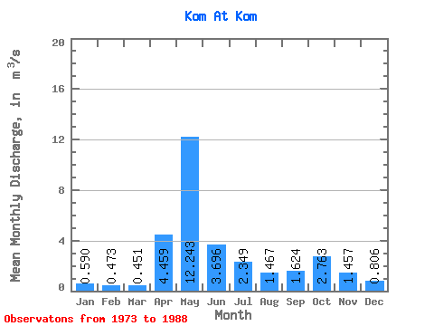
| Statistic | Jan | Feb | Mar | Apr | May | Jun | Jul | Aug | Sep | Oct | Nov | Dec | Annual |
|---|---|---|---|---|---|---|---|---|---|---|---|---|---|
| Mean | 0.59 | 0.47 | 0.45 | 4.46 | 12.24 | 3.70 | 2.35 | 1.47 | 1.62 | 2.76 | 1.46 | 0.81 | 2.69 |
| Standard Deviation | 0.31 | 0.26 | 0.16 | 3.74 | 6.40 | 2.51 | 1.48 | 0.95 | 0.98 | 1.68 | 0.92 | 0.32 | 0.57 |
| Min | 0.18 | 0.16 | 0.21 | 0.31 | 2.17 | 1.70 | 0.35 | 0.41 | 0.49 | 0.60 | 0.32 | 0.26 | 1.52 |
| Max | 1.37 | 1.03 | 0.78 | 11.70 | 25.20 | 11.00 | 5.37 | 3.07 | 3.51 | 5.65 | 4.04 | 1.47 | 3.38 |
| Coefficient of Variation | 0.52 | 0.55 | 0.36 | 0.84 | 0.52 | 0.68 | 0.63 | 0.65 | 0.60 | 0.61 | 0.63 | 0.40 | 0.21 |
 Return to R-Arctic Net Home Page