|
|
|||||||||||||||||
| Point ID: 7397 | Downloads | Plots | Site Data | Code: 70214 |
|
|
|||||||||||||||||
| Download | |
|---|---|
| Site Descriptor Information | Site Time Series Data |
| Link to all available data | |
| View: | Time Series | All |
| Units: | m3/s |
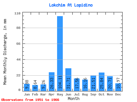
| Statistic | Jan | Feb | Mar | Apr | May | Jun | Jul | Aug | Sep | Oct | Nov | Dec | Annual |
|---|---|---|---|---|---|---|---|---|---|---|---|---|---|
| Mean | 9.87 | 8.71 | 9.26 | 26.33 | 104.09 | 31.71 | 17.55 | 16.16 | 21.51 | 25.84 | 20.70 | 10.97 | 301.63 |
| Standard Deviation | 1.81 | 1.38 | 1.36 | 18.83 | 25.71 | 11.77 | 6.36 | 9.79 | 14.72 | 9.58 | 9.99 | 1.94 | 52.41 |
| Min | 7.12 | 6.99 | 7.82 | 9.11 | 61.02 | 19.55 | 10.71 | 7.53 | 8.48 | 12.16 | 7.99 | 8.03 | 224.54 |
| Max | 14.77 | 12.46 | 11.94 | 79.16 | 159.23 | 55.48 | 34.02 | 43.57 | 63.96 | 40.68 | 40.84 | 14.19 | 399.48 |
| Coefficient of Variation | 0.18 | 0.16 | 0.15 | 0.71 | 0.25 | 0.37 | 0.36 | 0.61 | 0.68 | 0.37 | 0.48 | 0.18 | 0.17 |
 Return to R-Arctic Net Home Page