|
|
|||||||||||||||||
| Point ID: 7397 | Downloads | Plots | Site Data | Code: 70214 |
|
|
|||||||||||||||||
| Download | |
|---|---|
| Site Descriptor Information | Site Time Series Data |
| Link to all available data | |
| View: | Time Series | All |
| Units: | mm |
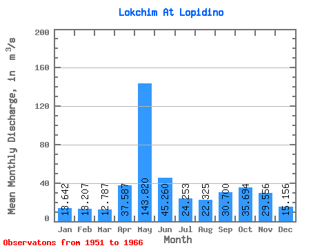
| Statistic | Jan | Feb | Mar | Apr | May | Jun | Jul | Aug | Sep | Oct | Nov | Dec | Annual |
|---|---|---|---|---|---|---|---|---|---|---|---|---|---|
| Mean | 13.64 | 13.21 | 12.79 | 37.59 | 143.82 | 45.26 | 24.25 | 22.32 | 30.70 | 35.69 | 29.56 | 15.16 | 35.36 |
| Standard Deviation | 2.50 | 2.09 | 1.88 | 26.88 | 35.52 | 16.80 | 8.79 | 13.52 | 21.01 | 13.23 | 14.26 | 2.68 | 6.14 |
| Min | 9.83 | 10.60 | 10.80 | 13.00 | 84.30 | 27.90 | 14.80 | 10.40 | 12.10 | 16.80 | 11.40 | 11.10 | 26.32 |
| Max | 20.40 | 18.90 | 16.50 | 113.00 | 220.00 | 79.20 | 47.00 | 60.20 | 91.30 | 56.20 | 58.30 | 19.60 | 46.83 |
| Coefficient of Variation | 0.18 | 0.16 | 0.15 | 0.71 | 0.25 | 0.37 | 0.36 | 0.61 | 0.68 | 0.37 | 0.48 | 0.18 | 0.17 |
 Return to R-Arctic Net Home Page