|
|
|||||||||||||||||
| Point ID: 7393 | Downloads | Plots | Site Data | Code: 70209 |
|
|
|||||||||||||||||
| Download | |
|---|---|
| Site Descriptor Information | Site Time Series Data |
| Link to all available data | |
| View: | Time Series | All |
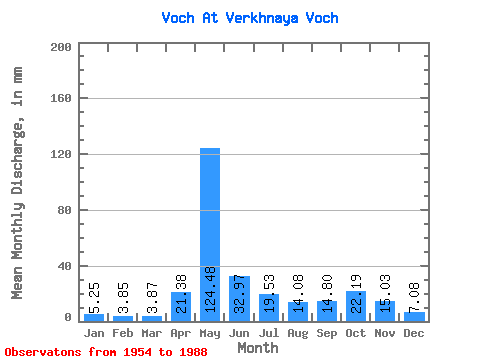
| Units: | m3/s |
| Statistic | Jan | Feb | Mar | Apr | May | Jun | Jul | Aug | Sep | Oct | Nov | Dec | Annual |
|---|---|---|---|---|---|---|---|---|---|---|---|---|---|
| Mean | 5.25 | 3.89 | 3.87 | 21.38 | 124.46 | 32.97 | 19.52 | 14.08 | 14.80 | 22.19 | 15.03 | 7.08 | 288.87 |
| Standard Deviation | 1.91 | 1.45 | 1.06 | 22.35 | 46.17 | 18.58 | 15.66 | 12.74 | 11.23 | 11.69 | 9.17 | 2.96 | 68.53 |
| Min | 2.65 | 1.48 | 1.42 | 3.06 | 31.97 | 7.55 | 4.33 | 2.66 | 3.69 | 6.98 | 2.64 | 3.65 | 156.67 |
| Max | 12.74 | 10.71 | 7.87 | 109.35 | 220.94 | 84.08 | 72.31 | 57.41 | 59.62 | 60.42 | 38.88 | 16.37 | 437.35 |
| Coefficient of Variation | 0.36 | 0.37 | 0.28 | 1.04 | 0.37 | 0.56 | 0.80 | 0.91 | 0.76 | 0.53 | 0.61 | 0.42 | 0.24 |
 Return to R-Arctic Net Home Page