|
|
|||||||||||||||||
| Point ID: 7393 | Downloads | Plots | Site Data | Code: 70209 |
|
|
|||||||||||||||||
| Download | |
|---|---|
| Site Descriptor Information | Site Time Series Data |
| Link to all available data | |
| View: | Time Series | All |
| Units: | mm |
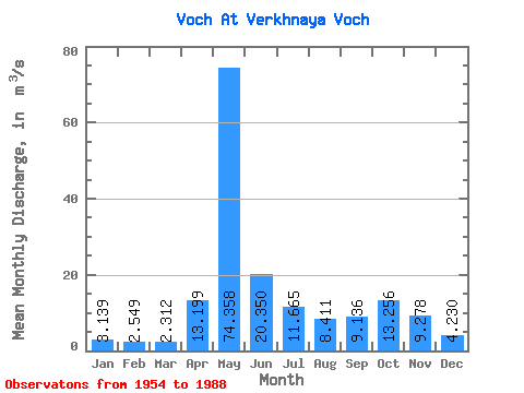
| Statistic | Jan | Feb | Mar | Apr | May | Jun | Jul | Aug | Sep | Oct | Nov | Dec | Annual |
|---|---|---|---|---|---|---|---|---|---|---|---|---|---|
| Mean | 3.14 | 2.55 | 2.31 | 13.20 | 74.36 | 20.35 | 11.66 | 8.41 | 9.14 | 13.26 | 9.28 | 4.23 | 14.64 |
| Standard Deviation | 1.14 | 0.95 | 0.64 | 13.79 | 27.59 | 11.47 | 9.36 | 7.61 | 6.93 | 6.98 | 5.66 | 1.77 | 3.48 |
| Min | 1.58 | 0.97 | 0.85 | 1.89 | 19.10 | 4.66 | 2.59 | 1.59 | 2.28 | 4.17 | 1.63 | 2.18 | 7.94 |
| Max | 7.61 | 7.02 | 4.70 | 67.50 | 132.00 | 51.90 | 43.20 | 34.30 | 36.80 | 36.10 | 24.00 | 9.78 | 22.17 |
| Coefficient of Variation | 0.36 | 0.37 | 0.28 | 1.04 | 0.37 | 0.56 | 0.80 | 0.91 | 0.76 | 0.53 | 0.61 | 0.42 | 0.24 |
 Return to R-Arctic Net Home Page