|
|
|||||||||||||||||
| Point ID: 7389 | Downloads | Plots | Site Data | Code: 70200 |
|
|
|||||||||||||||||
| Download | |
|---|---|
| Site Descriptor Information | Site Time Series Data |
| Link to all available data | |
| View: | Time Series | All |
| Units: | m3/s |
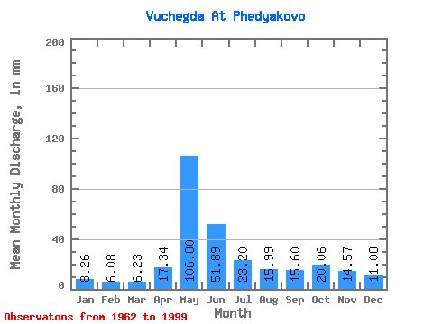
| Statistic | Jan | Feb | Mar | Apr | May | Jun | Jul | Aug | Sep | Oct | Nov | Dec | Annual |
|---|---|---|---|---|---|---|---|---|---|---|---|---|---|
| Mean | 8.26 | 6.14 | 6.23 | 17.34 | 106.78 | 51.89 | 23.20 | 15.99 | 15.60 | 20.06 | 14.57 | 11.08 | 294.08 |
| Standard Deviation | 1.75 | 1.06 | 0.99 | 15.36 | 26.80 | 22.62 | 10.01 | 6.62 | 5.52 | 7.04 | 4.85 | 3.11 | 45.31 |
| Min | 5.09 | 4.21 | 4.73 | 5.79 | 59.06 | 16.48 | 10.78 | 8.01 | 8.63 | 9.80 | 6.67 | 6.17 | 191.07 |
| Max | 12.07 | 8.98 | 9.18 | 68.04 | 157.81 | 111.55 | 52.60 | 41.60 | 36.57 | 44.71 | 28.00 | 23.24 | 372.54 |
| Coefficient of Variation | 0.21 | 0.17 | 0.16 | 0.89 | 0.25 | 0.44 | 0.43 | 0.41 | 0.35 | 0.35 | 0.33 | 0.28 | 0.15 |
 Return to R-Arctic Net Home Page