|
|
|||||||||||||||||
| Point ID: 7389 | Downloads | Plots | Site Data | Code: 70200 |
|
|
|||||||||||||||||
| Download | |
|---|---|
| Site Descriptor Information | Site Time Series Data |
| Link to all available data | |
| View: | Time Series | All |
| Units: | mm |
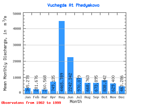
| Statistic | Jan | Feb | Mar | Apr | May | Jun | Jul | Aug | Sep | Oct | Nov | Dec | Annual |
|---|---|---|---|---|---|---|---|---|---|---|---|---|---|
| Mean | 345.28 | 281.68 | 260.57 | 749.13 | 4465.79 | 2242.34 | 970.08 | 668.76 | 673.89 | 838.84 | 629.40 | 463.29 | 1043.63 |
| Standard Deviation | 73.33 | 48.76 | 41.38 | 663.59 | 1120.99 | 977.25 | 418.79 | 277.01 | 238.49 | 294.49 | 209.67 | 129.93 | 160.78 |
| Min | 213.00 | 193.00 | 198.00 | 250.00 | 2470.00 | 712.00 | 451.00 | 335.00 | 373.00 | 410.00 | 288.00 | 258.00 | 678.08 |
| Max | 505.00 | 412.00 | 384.00 | 2940.00 | 6600.00 | 4820.00 | 2200.00 | 1740.00 | 1580.00 | 1870.00 | 1210.00 | 972.00 | 1322.08 |
| Coefficient of Variation | 0.21 | 0.17 | 0.16 | 0.89 | 0.25 | 0.44 | 0.43 | 0.41 | 0.35 | 0.35 | 0.33 | 0.28 | 0.15 |
 Return to R-Arctic Net Home Page