|
|
|||||||||||||||||
| Point ID: 7387 | Downloads | Plots | Site Data | Code: 70180 |
|
|
|||||||||||||||||
| Download | |
|---|---|
| Site Descriptor Information | Site Time Series Data |
| Link to all available data | |
| View: | Time Series | All |
| Units: | m3/s |
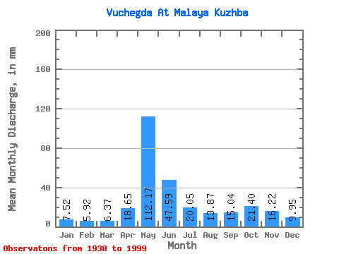
| Statistic | Jan | Feb | Mar | Apr | May | Jun | Jul | Aug | Sep | Oct | Nov | Dec | Annual |
|---|---|---|---|---|---|---|---|---|---|---|---|---|---|
| Mean | 7.52 | 5.97 | 6.37 | 18.65 | 112.16 | 47.59 | 20.04 | 13.87 | 15.04 | 21.39 | 16.22 | 9.95 | 293.22 |
| Standard Deviation | 1.86 | 1.25 | 1.31 | 16.74 | 32.05 | 26.04 | 10.66 | 7.42 | 7.06 | 8.93 | 6.25 | 3.05 | 52.69 |
| Min | 3.24 | 2.60 | 2.93 | 5.31 | 46.38 | 10.96 | 7.26 | 5.35 | 4.60 | 6.13 | 7.53 | 4.97 | 147.62 |
| Max | 12.33 | 8.90 | 10.21 | 87.54 | 179.88 | 121.29 | 53.46 | 48.91 | 41.47 | 53.05 | 37.46 | 19.81 | 409.37 |
| Coefficient of Variation | 0.25 | 0.21 | 0.21 | 0.90 | 0.29 | 0.55 | 0.53 | 0.54 | 0.47 | 0.42 | 0.39 | 0.31 | 0.18 |
 Return to R-Arctic Net Home Page