|
|
|||||||||||||||||
| Point ID: 7387 | Downloads | Plots | Site Data | Code: 70180 |
|
|
|||||||||||||||||
| Download | |
|---|---|
| Site Descriptor Information | Site Time Series Data |
| Link to all available data | |
| View: | Time Series | All |
| Units: | mm |
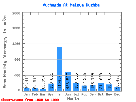
| Statistic | Jan | Feb | Mar | Apr | May | Jun | Jul | Aug | Sep | Oct | Nov | Dec | Annual |
|---|---|---|---|---|---|---|---|---|---|---|---|---|---|
| Mean | 74.41 | 64.81 | 62.99 | 190.68 | 1109.84 | 486.51 | 198.34 | 137.21 | 153.73 | 211.69 | 165.83 | 98.48 | 246.21 |
| Standard Deviation | 18.41 | 13.62 | 12.98 | 171.18 | 317.15 | 266.20 | 105.47 | 73.39 | 72.21 | 88.36 | 63.84 | 30.18 | 44.24 |
| Min | 32.10 | 28.20 | 29.00 | 54.30 | 459.00 | 112.00 | 71.80 | 52.90 | 47.00 | 60.70 | 77.00 | 49.20 | 123.95 |
| Max | 122.00 | 96.70 | 101.00 | 895.00 | 1780.00 | 1240.00 | 529.00 | 484.00 | 424.00 | 525.00 | 383.00 | 196.00 | 343.73 |
| Coefficient of Variation | 0.25 | 0.21 | 0.21 | 0.90 | 0.29 | 0.55 | 0.53 | 0.54 | 0.47 | 0.42 | 0.39 | 0.31 | 0.18 |
 Return to R-Arctic Net Home Page