|
|
|||||||||||||||||
| Point ID: 7381 | Downloads | Plots | Site Data | Code: 70169 |
|
|
|||||||||||||||||
| Download | |
|---|---|
| Site Descriptor Information | Site Time Series Data |
| Link to all available data | |
| View: | Time Series | All |
| Units: | m3/s |
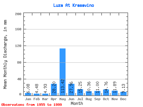
| Statistic | Jan | Feb | Mar | Apr | May | Jun | Jul | Aug | Sep | Oct | Nov | Dec | Annual |
|---|---|---|---|---|---|---|---|---|---|---|---|---|---|
| Mean | 6.08 | 4.52 | 4.92 | 28.20 | 113.41 | 27.96 | 15.24 | 10.36 | 11.00 | 14.76 | 11.89 | 9.13 | 255.86 |
| Standard Deviation | 2.63 | 1.47 | 1.79 | 24.52 | 42.48 | 15.90 | 9.85 | 8.70 | 13.12 | 8.55 | 6.00 | 5.43 | 67.43 |
| Min | 2.46 | 1.69 | 2.45 | 3.90 | 16.92 | 6.76 | 4.67 | 3.88 | 4.13 | 5.65 | 4.04 | 2.53 | 138.13 |
| Max | 16.43 | 8.38 | 9.84 | 105.43 | 208.65 | 73.94 | 48.14 | 50.77 | 88.89 | 35.49 | 30.85 | 32.53 | 404.41 |
| Coefficient of Variation | 0.43 | 0.32 | 0.36 | 0.87 | 0.38 | 0.57 | 0.65 | 0.84 | 1.19 | 0.58 | 0.51 | 0.59 | 0.26 |
 Return to R-Arctic Net Home Page