|
|
|||||||||||||||||
| Point ID: 7381 | Downloads | Plots | Site Data | Code: 70169 |
|
|
|||||||||||||||||
| Download | |
|---|---|
| Site Descriptor Information | Site Time Series Data |
| Link to all available data | |
| View: | Time Series | All |
| Units: | mm |
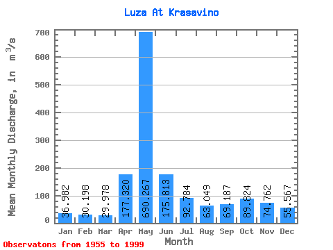
| Statistic | Jan | Feb | Mar | Apr | May | Jun | Jul | Aug | Sep | Oct | Nov | Dec | Annual |
|---|---|---|---|---|---|---|---|---|---|---|---|---|---|
| Mean | 36.98 | 30.20 | 29.98 | 177.32 | 690.27 | 175.81 | 92.78 | 63.05 | 69.19 | 89.82 | 74.76 | 55.57 | 132.14 |
| Standard Deviation | 16.02 | 9.79 | 10.89 | 154.19 | 258.57 | 100.02 | 59.92 | 52.97 | 82.49 | 52.03 | 37.74 | 33.03 | 34.83 |
| Min | 15.00 | 11.30 | 14.90 | 24.50 | 103.00 | 42.50 | 28.40 | 23.60 | 26.00 | 34.40 | 25.40 | 15.40 | 71.34 |
| Max | 100.00 | 56.00 | 59.90 | 663.00 | 1270.00 | 465.00 | 293.00 | 309.00 | 559.00 | 216.00 | 194.00 | 198.00 | 208.87 |
| Coefficient of Variation | 0.43 | 0.32 | 0.36 | 0.87 | 0.38 | 0.57 | 0.65 | 0.84 | 1.19 | 0.58 | 0.51 | 0.59 | 0.26 |
 Return to R-Arctic Net Home Page