|
|
|||||||||||||||||
| Point ID: 7378 | Downloads | Plots | Site Data | Code: 70163 |
|
|
|||||||||||||||||
| Download | |
|---|---|
| Site Descriptor Information | Site Time Series Data |
| Link to all available data | |
| View: | Time Series | All |
| Units: | m3/s |
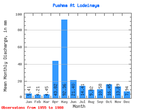
| Statistic | Jan | Feb | Mar | Apr | May | Jun | Jul | Aug | Sep | Oct | Nov | Dec | Annual |
|---|---|---|---|---|---|---|---|---|---|---|---|---|---|
| Mean | 5.41 | 4.24 | 4.45 | 43.82 | 92.34 | 21.40 | 14.40 | 9.82 | 10.58 | 16.45 | 13.89 | 7.94 | 243.69 |
| Standard Deviation | 1.85 | 1.07 | 1.15 | 30.30 | 47.29 | 12.99 | 9.47 | 6.11 | 7.30 | 9.82 | 7.15 | 4.55 | 58.92 |
| Min | 2.76 | 2.50 | 2.64 | 6.69 | 20.49 | 6.40 | 4.77 | 3.52 | 3.29 | 5.68 | 4.70 | 2.21 | 103.21 |
| Max | 12.13 | 6.54 | 7.36 | 125.17 | 203.71 | 66.35 | 40.06 | 28.61 | 29.24 | 44.18 | 27.47 | 22.32 | 360.25 |
| Coefficient of Variation | 0.34 | 0.25 | 0.26 | 0.69 | 0.51 | 0.61 | 0.66 | 0.62 | 0.69 | 0.60 | 0.52 | 0.57 | 0.24 |
 Return to R-Arctic Net Home Page