|
|
|||||||||||||||||
| Point ID: 7378 | Downloads | Plots | Site Data | Code: 70163 |
|
|
|||||||||||||||||
| Download | |
|---|---|
| Site Descriptor Information | Site Time Series Data |
| Link to all available data | |
| View: | Time Series | All |
| Units: | mm |
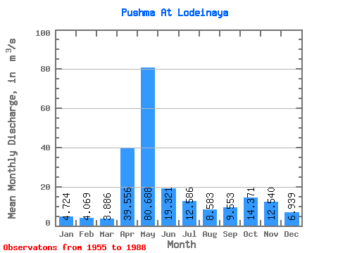
| Statistic | Jan | Feb | Mar | Apr | May | Jun | Jul | Aug | Sep | Oct | Nov | Dec | Annual |
|---|---|---|---|---|---|---|---|---|---|---|---|---|---|
| Mean | 4.72 | 4.07 | 3.89 | 39.56 | 80.69 | 19.32 | 12.59 | 8.58 | 9.55 | 14.37 | 12.54 | 6.94 | 18.07 |
| Standard Deviation | 1.62 | 1.03 | 1.00 | 27.36 | 41.32 | 11.73 | 8.28 | 5.34 | 6.59 | 8.58 | 6.46 | 3.98 | 4.37 |
| Min | 2.41 | 2.40 | 2.31 | 6.04 | 17.90 | 5.78 | 4.17 | 3.08 | 2.97 | 4.96 | 4.24 | 1.93 | 7.65 |
| Max | 10.60 | 6.27 | 6.43 | 113.00 | 178.00 | 59.90 | 35.00 | 25.00 | 26.40 | 38.60 | 24.80 | 19.50 | 26.71 |
| Coefficient of Variation | 0.34 | 0.25 | 0.26 | 0.69 | 0.51 | 0.61 | 0.66 | 0.62 | 0.69 | 0.60 | 0.52 | 0.57 | 0.24 |
 Return to R-Arctic Net Home Page