|
|
|||||||||||||||||
| Point ID: 7371 | Downloads | Plots | Site Data | Code: 70153 |
|
|
|||||||||||||||||
| Download | |
|---|---|
| Site Descriptor Information | Site Time Series Data |
| Link to all available data | |
| View: | Time Series | All |
| Units: | m3/s |
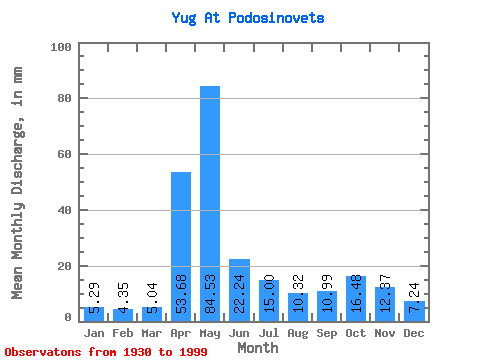
| Statistic | Jan | Feb | Mar | Apr | May | Jun | Jul | Aug | Sep | Oct | Nov | Dec | Annual |
|---|---|---|---|---|---|---|---|---|---|---|---|---|---|
| Mean | 5.29 | 4.38 | 5.04 | 53.68 | 84.52 | 22.24 | 15.00 | 10.31 | 10.99 | 16.48 | 12.37 | 7.24 | 246.55 |
| Standard Deviation | 1.83 | 1.22 | 1.35 | 29.89 | 41.65 | 14.28 | 12.10 | 7.94 | 12.07 | 13.19 | 7.10 | 3.45 | 65.50 |
| Min | 2.15 | 2.13 | 2.06 | 5.54 | 19.38 | 5.58 | 4.21 | 2.61 | 3.04 | 4.28 | 4.02 | 2.41 | 114.59 |
| Max | 11.80 | 7.53 | 10.73 | 143.41 | 183.23 | 78.95 | 58.67 | 45.98 | 85.09 | 93.20 | 47.24 | 19.38 | 527.49 |
| Coefficient of Variation | 0.34 | 0.28 | 0.27 | 0.56 | 0.49 | 0.64 | 0.81 | 0.77 | 1.10 | 0.80 | 0.57 | 0.48 | 0.27 |
 Return to R-Arctic Net Home Page