|
|
|||||||||||||||||
| Point ID: 7371 | Downloads | Plots | Site Data | Code: 70153 |
|
|
|||||||||||||||||
| Download | |
|---|---|
| Site Descriptor Information | Site Time Series Data |
| Link to all available data | |
| View: | Time Series | All |
| Units: | mm |
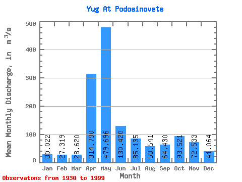
| Statistic | Jan | Feb | Mar | Apr | May | Jun | Jul | Aug | Sep | Oct | Nov | Dec | Annual |
|---|---|---|---|---|---|---|---|---|---|---|---|---|---|
| Mean | 30.02 | 27.32 | 28.62 | 314.79 | 479.70 | 130.42 | 85.14 | 58.54 | 64.43 | 93.52 | 72.53 | 41.06 | 118.75 |
| Standard Deviation | 10.37 | 7.57 | 7.65 | 175.29 | 236.40 | 83.72 | 68.67 | 45.06 | 70.77 | 74.89 | 41.66 | 19.60 | 31.55 |
| Min | 12.20 | 13.30 | 11.70 | 32.50 | 110.00 | 32.70 | 23.90 | 14.80 | 17.80 | 24.30 | 23.60 | 13.70 | 55.19 |
| Max | 67.00 | 46.90 | 60.90 | 841.00 | 1040.00 | 463.00 | 333.00 | 261.00 | 499.00 | 529.00 | 277.00 | 110.00 | 254.05 |
| Coefficient of Variation | 0.34 | 0.28 | 0.27 | 0.56 | 0.49 | 0.64 | 0.81 | 0.77 | 1.10 | 0.80 | 0.57 | 0.48 | 0.27 |
 Return to R-Arctic Net Home Page