|
|
|||||||||||||||||
| Point ID: 7370 | Downloads | Plots | Site Data | Code: 70152 |
|
|
|||||||||||||||||
| Download | |
|---|---|
| Site Descriptor Information | Site Time Series Data |
| Link to all available data | |
| View: | Time Series | All |
| Units: | m3/s |
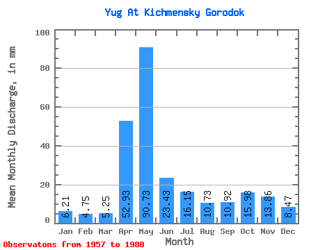
| Statistic | Jan | Feb | Mar | Apr | May | Jun | Jul | Aug | Sep | Oct | Nov | Dec | Annual |
|---|---|---|---|---|---|---|---|---|---|---|---|---|---|
| Mean | 6.21 | 4.79 | 5.25 | 52.93 | 90.71 | 23.43 | 16.14 | 10.72 | 10.92 | 15.98 | 13.86 | 8.47 | 258.53 |
| Standard Deviation | 1.90 | 0.99 | 1.35 | 31.12 | 46.18 | 15.95 | 11.86 | 7.52 | 5.94 | 8.38 | 7.94 | 4.17 | 59.86 |
| Min | 2.87 | 3.21 | 3.46 | 7.46 | 17.44 | 7.67 | 5.18 | 3.89 | 5.04 | 7.05 | 4.67 | 3.71 | 156.53 |
| Max | 11.84 | 7.11 | 10.94 | 137.62 | 174.72 | 77.26 | 49.10 | 37.35 | 28.11 | 34.04 | 35.57 | 22.86 | 396.75 |
| Coefficient of Variation | 0.31 | 0.21 | 0.26 | 0.59 | 0.51 | 0.68 | 0.73 | 0.70 | 0.54 | 0.53 | 0.57 | 0.49 | 0.23 |
 Return to R-Arctic Net Home Page