|
|
|||||||||||||||||
| Point ID: 7370 | Downloads | Plots | Site Data | Code: 70152 |
|
|
|||||||||||||||||
| Download | |
|---|---|
| Site Descriptor Information | Site Time Series Data |
| Link to all available data | |
| View: | Time Series | All |
| Units: | mm |
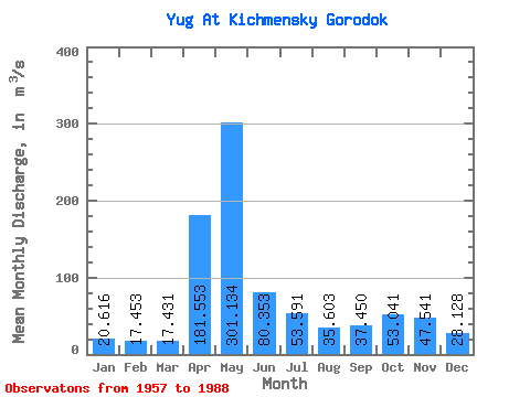
| Statistic | Jan | Feb | Mar | Apr | May | Jun | Jul | Aug | Sep | Oct | Nov | Dec | Annual |
|---|---|---|---|---|---|---|---|---|---|---|---|---|---|
| Mean | 20.62 | 17.45 | 17.43 | 181.55 | 301.13 | 80.35 | 53.59 | 35.60 | 37.45 | 53.04 | 47.54 | 28.13 | 72.83 |
| Standard Deviation | 6.31 | 3.63 | 4.50 | 106.74 | 153.30 | 54.70 | 39.37 | 24.95 | 20.36 | 27.83 | 27.24 | 13.84 | 16.86 |
| Min | 9.52 | 11.70 | 11.50 | 25.60 | 57.90 | 26.30 | 17.20 | 12.90 | 17.30 | 23.40 | 16.00 | 12.30 | 44.09 |
| Max | 39.30 | 25.90 | 36.30 | 472.00 | 580.00 | 265.00 | 163.00 | 124.00 | 96.40 | 113.00 | 122.00 | 75.90 | 111.76 |
| Coefficient of Variation | 0.31 | 0.21 | 0.26 | 0.59 | 0.51 | 0.68 | 0.73 | 0.70 | 0.54 | 0.53 | 0.57 | 0.49 | 0.23 |
 Return to R-Arctic Net Home Page