|
|
|||||||||||||||||
| Point ID: 7365 | Downloads | Plots | Site Data | Code: 70143 |
|
|
|||||||||||||||||
| Download | |
|---|---|
| Site Descriptor Information | Site Time Series Data |
| Link to all available data | |
| View: | Time Series | All |
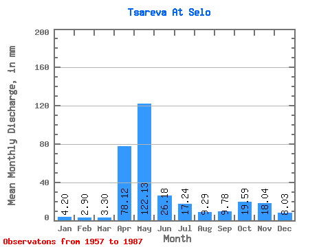
| Units: | m3/s |
| Statistic | Jan | Feb | Mar | Apr | May | Jun | Jul | Aug | Sep | Oct | Nov | Dec | Annual |
|---|---|---|---|---|---|---|---|---|---|---|---|---|---|
| Mean | 4.20 | 2.92 | 3.30 | 78.12 | 122.11 | 26.18 | 17.24 | 9.29 | 9.78 | 19.59 | 18.04 | 8.03 | 321.66 |
| Standard Deviation | 1.71 | 1.11 | 1.13 | 52.33 | 68.96 | 24.32 | 17.22 | 13.16 | 8.45 | 18.50 | 14.88 | 5.40 | 90.14 |
| Min | 1.45 | 1.08 | 1.21 | 8.32 | 11.71 | 3.56 | 3.19 | 2.09 | 1.88 | 2.11 | 3.67 | 2.60 | 185.53 |
| Max | 9.98 | 6.75 | 5.39 | 219.04 | 281.00 | 129.05 | 57.52 | 75.44 | 37.05 | 76.94 | 70.09 | 23.20 | 571.56 |
| Coefficient of Variation | 0.41 | 0.38 | 0.34 | 0.67 | 0.56 | 0.93 | 1.00 | 1.42 | 0.86 | 0.94 | 0.82 | 0.67 | 0.28 |
 Return to R-Arctic Net Home Page