|
|
|||||||||||||||||
| Point ID: 7365 | Downloads | Plots | Site Data | Code: 70143 |
|
|
|||||||||||||||||
| Download | |
|---|---|
| Site Descriptor Information | Site Time Series Data |
| Link to all available data | |
| View: | Time Series | All |
| Units: | mm |
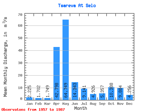
| Statistic | Jan | Feb | Mar | Apr | May | Jun | Jul | Aug | Sep | Oct | Nov | Dec | Annual |
|---|---|---|---|---|---|---|---|---|---|---|---|---|---|
| Mean | 2.23 | 1.70 | 1.75 | 42.80 | 64.75 | 14.34 | 9.14 | 4.93 | 5.36 | 10.39 | 9.88 | 4.26 | 14.47 |
| Standard Deviation | 0.91 | 0.65 | 0.60 | 28.67 | 36.56 | 13.33 | 9.13 | 6.98 | 4.63 | 9.81 | 8.15 | 2.86 | 4.06 |
| Min | 0.77 | 0.63 | 0.64 | 4.56 | 6.21 | 1.95 | 1.69 | 1.11 | 1.03 | 1.12 | 2.01 | 1.38 | 8.35 |
| Max | 5.29 | 3.93 | 2.86 | 120.00 | 149.00 | 70.70 | 30.50 | 40.00 | 20.30 | 40.80 | 38.40 | 12.30 | 25.72 |
| Coefficient of Variation | 0.41 | 0.38 | 0.34 | 0.67 | 0.56 | 0.93 | 1.00 | 1.42 | 0.86 | 0.94 | 0.82 | 0.67 | 0.28 |
 Return to R-Arctic Net Home Page