|
|
|||||||||||||||||
| Point ID: 7342 | Downloads | Plots | Site Data | Code: 70027 |
|
|
|||||||||||||||||
| Download | |
|---|---|
| Site Descriptor Information | Site Time Series Data |
| Link to all available data | |
| View: | Time Series | All |
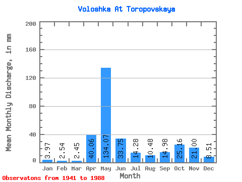
| Units: | m3/s |
| Statistic | Jan | Feb | Mar | Apr | May | Jun | Jul | Aug | Sep | Oct | Nov | Dec | Annual |
|---|---|---|---|---|---|---|---|---|---|---|---|---|---|
| Mean | 3.97 | 2.56 | 2.45 | 40.06 | 134.05 | 33.74 | 14.28 | 10.48 | 14.98 | 25.15 | 21.00 | 8.51 | 309.18 |
| Standard Deviation | 2.32 | 1.40 | 1.00 | 37.61 | 54.69 | 23.87 | 10.27 | 13.40 | 16.33 | 17.01 | 15.38 | 6.34 | 80.23 |
| Min | 1.34 | 0.97 | 1.04 | 1.52 | 35.45 | 6.41 | 3.45 | 1.60 | 1.57 | 2.62 | 2.37 | 1.75 | 173.78 |
| Max | 14.04 | 7.07 | 4.98 | 155.00 | 278.07 | 121.87 | 44.89 | 74.56 | 66.64 | 74.56 | 71.80 | 42.22 | 498.58 |
| Coefficient of Variation | 0.58 | 0.54 | 0.41 | 0.94 | 0.41 | 0.71 | 0.72 | 1.28 | 1.09 | 0.68 | 0.73 | 0.74 | 0.26 |
 Return to R-Arctic Net Home Page