|
|
|||||||||||||||||
| Point ID: 7342 | Downloads | Plots | Site Data | Code: 70027 |
|
|
|||||||||||||||||
| Download | |
|---|---|
| Site Descriptor Information | Site Time Series Data |
| Link to all available data | |
| View: | Time Series | All |
| Units: | mm |
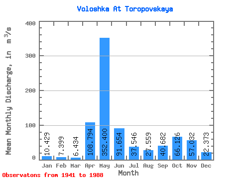
| Statistic | Jan | Feb | Mar | Apr | May | Jun | Jul | Aug | Sep | Oct | Nov | Dec | Annual |
|---|---|---|---|---|---|---|---|---|---|---|---|---|---|
| Mean | 10.43 | 7.40 | 6.43 | 108.79 | 352.40 | 91.65 | 37.55 | 27.56 | 40.68 | 66.13 | 57.03 | 22.37 | 68.97 |
| Standard Deviation | 6.10 | 4.03 | 2.62 | 102.15 | 143.76 | 64.82 | 26.99 | 35.23 | 44.36 | 44.72 | 41.77 | 16.67 | 17.90 |
| Min | 3.53 | 2.80 | 2.73 | 4.13 | 93.20 | 17.40 | 9.08 | 4.22 | 4.26 | 6.90 | 6.44 | 4.61 | 38.76 |
| Max | 36.90 | 20.40 | 13.10 | 421.00 | 731.00 | 331.00 | 118.00 | 196.00 | 181.00 | 196.00 | 195.00 | 111.00 | 111.22 |
| Coefficient of Variation | 0.58 | 0.54 | 0.41 | 0.94 | 0.41 | 0.71 | 0.72 | 1.28 | 1.09 | 0.68 | 0.73 | 0.74 | 0.26 |
 Return to R-Arctic Net Home Page