|
|
|||||||||||||||||
| Point ID: 7320 | Downloads | Plots | Site Data | Code: 49126 |
|
|
|||||||||||||||||
| Download | |
|---|---|
| Site Descriptor Information | Site Time Series Data |
| Link to all available data | |
| View: | Time Series | All |
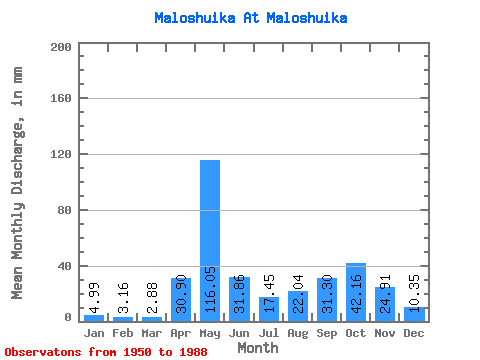
| Units: | m3/s |
| Statistic | Jan | Feb | Mar | Apr | May | Jun | Jul | Aug | Sep | Oct | Nov | Dec | Annual |
|---|---|---|---|---|---|---|---|---|---|---|---|---|---|
| Mean | 4.99 | 3.19 | 2.88 | 30.90 | 116.03 | 31.86 | 17.45 | 22.04 | 31.30 | 42.15 | 24.90 | 10.34 | 338.61 |
| Standard Deviation | 2.07 | 1.30 | 1.05 | 33.81 | 49.89 | 15.88 | 13.68 | 24.98 | 26.15 | 30.27 | 14.70 | 8.54 | 93.61 |
| Min | 2.23 | 1.06 | 0.78 | 1.35 | 28.62 | 6.74 | 2.12 | 1.50 | 2.64 | 3.79 | 3.07 | 3.01 | 184.10 |
| Max | 9.91 | 6.39 | 5.96 | 171.36 | 251.10 | 71.13 | 65.70 | 93.53 | 103.46 | 151.44 | 64.67 | 46.04 | 536.17 |
| Coefficient of Variation | 0.41 | 0.41 | 0.36 | 1.09 | 0.43 | 0.50 | 0.78 | 1.13 | 0.83 | 0.72 | 0.59 | 0.83 | 0.28 |
 Return to R-Arctic Net Home Page