|
|
|||||||||||||||||
| Point ID: 7320 | Downloads | Plots | Site Data | Code: 49126 |
|
|
|||||||||||||||||
| Download | |
|---|---|
| Site Descriptor Information | Site Time Series Data |
| Link to all available data | |
| View: | Time Series | All |
| Units: | mm |
| Statistic | Jan | Feb | Mar | Apr | May | Jun | Jul | Aug | Sep | Oct | Nov | Dec | Annual |
|---|---|---|---|---|---|---|---|---|---|---|---|---|---|
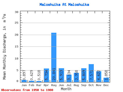
| Mean | 0.90 | 0.63 | 0.52 | 5.73 | 20.84 | 5.91 | 3.13 | 3.96 | 5.81 | 7.57 | 4.62 | 1.86 | 5.16 |
| Standard Deviation | 0.37 | 0.26 | 0.19 | 6.27 | 8.96 | 2.95 | 2.46 | 4.49 | 4.85 | 5.44 | 2.73 | 1.53 | 1.43 |
| Min | 0.40 | 0.21 | 0.14 | 0.25 | 5.14 | 1.25 | 0.38 | 0.27 | 0.49 | 0.68 | 0.57 | 0.54 | 2.81 |
| Max | 1.78 | 1.26 | 1.07 | 31.80 | 45.10 | 13.20 | 11.80 | 16.80 | 19.20 | 27.20 | 12.00 | 8.27 | 8.17 |
| Coefficient of Variation | 0.41 | 0.41 | 0.36 | 1.09 | 0.43 | 0.50 | 0.78 | 1.13 | 0.83 | 0.72 | 0.59 | 0.83 | 0.28 |
 Return to R-Arctic Net Home Page