|
|
|||||||||||||||||
| Point ID: 7297 | Downloads | Plots | Site Data | Code: 49069 |
|
|
|||||||||||||||||
| Download | |
|---|---|
| Site Descriptor Information | Site Time Series Data |
| Link to all available data | |
| View: | Time Series | All |
| Units: | m3/s |
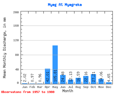
| Statistic | Jan | Feb | Mar | Apr | May | Jun | Jul | Aug | Sep | Oct | Nov | Dec | Annual |
|---|---|---|---|---|---|---|---|---|---|---|---|---|---|
| Mean | 2.02 | 0.97 | 0.96 | 42.01 | 105.80 | 24.48 | 12.13 | 16.58 | 22.16 | 27.21 | 14.05 | 4.65 | 270.56 |
| Standard Deviation | 2.19 | 0.66 | 0.62 | 41.99 | 53.71 | 24.07 | 16.36 | 22.75 | 22.35 | 20.01 | 9.26 | 4.29 | 82.02 |
| Min | 0.36 | 0.28 | 0.39 | 0.86 | 19.82 | 2.07 | 0.65 | 0.58 | 0.85 | 2.77 | 0.70 | 0.43 | 147.13 |
| Max | 12.23 | 3.58 | 3.57 | 147.74 | 192.82 | 111.46 | 60.52 | 99.09 | 82.08 | 68.47 | 34.30 | 22.58 | 467.32 |
| Coefficient of Variation | 1.08 | 0.68 | 0.64 | 1.00 | 0.51 | 0.98 | 1.35 | 1.37 | 1.01 | 0.73 | 0.66 | 0.92 | 0.30 |
 Return to R-Arctic Net Home Page