|
|
|||||||||||||||||
| Point ID: 7297 | Downloads | Plots | Site Data | Code: 49069 |
|
|
|||||||||||||||||
| Download | |
|---|---|
| Site Descriptor Information | Site Time Series Data |
| Link to all available data | |
| View: | Time Series | All |
| Units: | mm |
| Statistic | Jan | Feb | Mar | Apr | May | Jun | Jul | Aug | Sep | Oct | Nov | Dec | Annual |
|---|---|---|---|---|---|---|---|---|---|---|---|---|---|
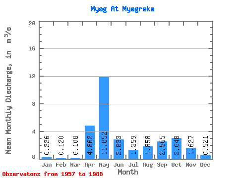
| Mean | 0.23 | 0.12 | 0.11 | 4.86 | 11.85 | 2.83 | 1.36 | 1.86 | 2.56 | 3.05 | 1.63 | 0.52 | 2.57 |
| Standard Deviation | 0.24 | 0.08 | 0.07 | 4.86 | 6.02 | 2.79 | 1.83 | 2.55 | 2.59 | 2.24 | 1.07 | 0.48 | 0.78 |
| Min | 0.04 | 0.03 | 0.04 | 0.10 | 2.22 | 0.24 | 0.07 | 0.07 | 0.10 | 0.31 | 0.08 | 0.05 | 1.40 |
| Max | 1.37 | 0.44 | 0.40 | 17.10 | 21.60 | 12.90 | 6.78 | 11.10 | 9.50 | 7.67 | 3.97 | 2.53 | 4.44 |
| Coefficient of Variation | 1.08 | 0.68 | 0.64 | 1.00 | 0.51 | 0.98 | 1.35 | 1.37 | 1.01 | 0.73 | 0.66 | 0.92 | 0.30 |
 Return to R-Arctic Net Home Page