|
|
|||||||||||||||||
| Point ID: 7269 | Downloads | Plots | Site Data | Code: 49013 |
|
|
|||||||||||||||||
| Download | |
|---|---|
| Site Descriptor Information | Site Time Series Data |
| Link to all available data | |
| View: | Time Series | All |
| Units: | m3/s |
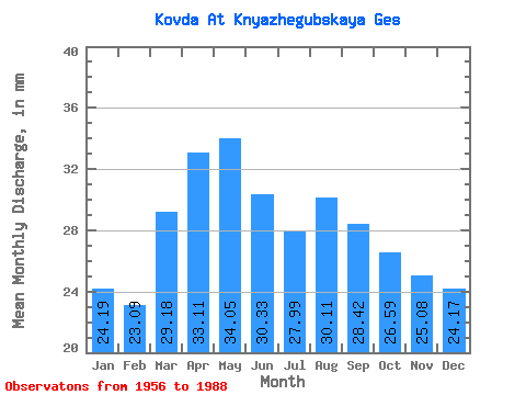
| Statistic | Jan | Feb | Mar | Apr | May | Jun | Jul | Aug | Sep | Oct | Nov | Dec | Annual |
|---|---|---|---|---|---|---|---|---|---|---|---|---|---|
| Mean | 24.19 | 23.29 | 29.17 | 33.11 | 34.05 | 30.33 | 27.98 | 30.11 | 28.42 | 26.59 | 25.08 | 24.17 | 336.50 |
| Standard Deviation | 6.06 | 6.20 | 7.89 | 8.60 | 12.04 | 19.06 | 8.89 | 8.55 | 6.96 | 7.43 | 9.14 | 7.86 | 61.88 |
| Min | 7.49 | 3.62 | 7.93 | 9.17 | 11.79 | 7.16 | 10.11 | 15.72 | 14.41 | 11.48 | 2.59 | 7.30 | 177.50 |
| Max | 34.53 | 32.60 | 43.74 | 50.34 | 77.96 | 102.08 | 45.39 | 49.42 | 47.94 | 40.33 | 43.53 | 40.22 | 487.11 |
| Coefficient of Variation | 0.25 | 0.27 | 0.27 | 0.26 | 0.35 | 0.63 | 0.32 | 0.28 | 0.24 | 0.28 | 0.36 | 0.33 | 0.18 |
 Return to R-Arctic Net Home Page