|
|
|||||||||||||||||
| Point ID: 7269 | Downloads | Plots | Site Data | Code: 49013 |
|
|
|||||||||||||||||
| Download | |
|---|---|
| Site Descriptor Information | Site Time Series Data |
| Link to all available data | |
| View: | Time Series | All |
| Units: | mm |
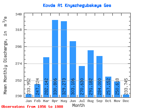
| Statistic | Jan | Feb | Mar | Apr | May | Jun | Jul | Aug | Sep | Oct | Nov | Dec | Annual |
|---|---|---|---|---|---|---|---|---|---|---|---|---|---|
| Mean | 233.95 | 247.22 | 282.14 | 330.81 | 329.27 | 303.11 | 270.63 | 291.18 | 284.00 | 257.15 | 250.62 | 233.75 | 276.15 |
| Standard Deviation | 58.61 | 65.80 | 76.35 | 85.88 | 116.43 | 190.41 | 85.95 | 82.70 | 69.54 | 71.83 | 91.29 | 76.00 | 50.78 |
| Min | 72.40 | 38.40 | 76.70 | 91.60 | 114.00 | 71.50 | 97.80 | 152.00 | 144.00 | 111.00 | 25.90 | 70.60 | 145.67 |
| Max | 334.00 | 346.00 | 423.00 | 503.00 | 754.00 | 1020.00 | 439.00 | 478.00 | 479.00 | 390.00 | 435.00 | 389.00 | 399.75 |
| Coefficient of Variation | 0.25 | 0.27 | 0.27 | 0.26 | 0.35 | 0.63 | 0.32 | 0.28 | 0.24 | 0.28 | 0.36 | 0.33 | 0.18 |
 Return to R-Arctic Net Home Page