|
|
|||||||||||||||||
| Point ID: 7265 | Downloads | Plots | Site Data | Code: 49004 |
|
|
|||||||||||||||||
| Download | |
|---|---|
| Site Descriptor Information | Site Time Series Data |
| Link to all available data | |
| View: | Time Series | All |
| Units: | m3/s |
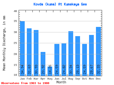
| Statistic | Jan | Feb | Mar | Apr | May | Jun | Jul | Aug | Sep | Oct | Nov | Dec | Annual |
|---|---|---|---|---|---|---|---|---|---|---|---|---|---|
| Mean | 34.93 | 31.91 | 30.92 | 20.92 | 14.26 | 24.59 | 24.82 | 30.34 | 28.12 | 24.59 | 28.67 | 32.33 | 326.93 |
| Standard Deviation | 9.55 | 11.02 | 9.73 | 11.72 | 13.48 | 18.67 | 14.08 | 13.57 | 12.92 | 10.55 | 10.75 | 9.29 | 78.96 |
| Min | 16.35 | 9.78 | 9.45 | 0.66 | 0.49 | 0.33 | 0.51 | 1.98 | 1.86 | 3.92 | 6.38 | 5.15 | 177.24 |
| Max | 48.08 | 47.51 | 47.88 | 48.30 | 62.69 | 73.44 | 49.10 | 51.12 | 48.50 | 39.56 | 47.72 | 47.88 | 481.97 |
| Coefficient of Variation | 0.27 | 0.34 | 0.32 | 0.56 | 0.94 | 0.76 | 0.57 | 0.45 | 0.46 | 0.43 | 0.38 | 0.29 | 0.24 |
 Return to R-Arctic Net Home Page