|
|
|||||||||||||||||
| Point ID: 7265 | Downloads | Plots | Site Data | Code: 49004 |
|
|
|||||||||||||||||
| Download | |
|---|---|
| Site Descriptor Information | Site Time Series Data |
| Link to all available data | |
| View: | Time Series | All |
| Units: | mm |
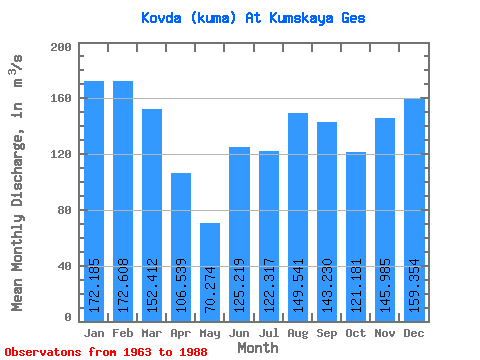
| Statistic | Jan | Feb | Mar | Apr | May | Jun | Jul | Aug | Sep | Oct | Nov | Dec | Annual |
|---|---|---|---|---|---|---|---|---|---|---|---|---|---|
| Mean | 172.19 | 172.61 | 152.41 | 106.54 | 70.27 | 125.22 | 122.32 | 149.54 | 143.23 | 121.18 | 145.99 | 159.35 | 136.74 |
| Standard Deviation | 47.06 | 59.62 | 47.97 | 59.69 | 66.42 | 95.06 | 69.42 | 66.88 | 65.79 | 51.99 | 54.76 | 45.80 | 33.02 |
| Min | 80.60 | 52.90 | 46.60 | 3.34 | 2.41 | 1.70 | 2.49 | 9.77 | 9.45 | 19.30 | 32.50 | 25.40 | 74.13 |
| Max | 237.00 | 257.00 | 236.00 | 246.00 | 309.00 | 374.00 | 242.00 | 252.00 | 247.00 | 195.00 | 243.00 | 236.00 | 201.58 |
| Coefficient of Variation | 0.27 | 0.34 | 0.32 | 0.56 | 0.94 | 0.76 | 0.57 | 0.45 | 0.46 | 0.43 | 0.38 | 0.29 | 0.24 |
 Return to R-Arctic Net Home Page