|
|
|||||||||||||||||
| Point ID: 7254 | Downloads | Plots | Site Data | Code: 12554 |
|
|
|||||||||||||||||
| Download | |
|---|---|
| Site Descriptor Information | Site Time Series Data |
| Link to all available data | |
| View: | Time Series | All |
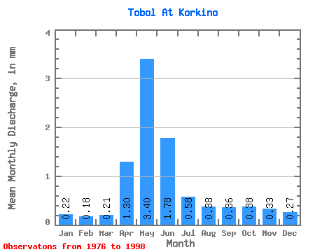
| Units: | m3/s |
| Statistic | Jan | Feb | Mar | Apr | May | Jun | Jul | Aug | Sep | Oct | Nov | Dec | Annual |
|---|---|---|---|---|---|---|---|---|---|---|---|---|---|
| Mean | 0.14 | 0.11 | 0.13 | 0.84 | 2.19 | 1.14 | 0.37 | 0.25 | 0.23 | 0.24 | 0.21 | 0.17 | 6.14 |
| Standard Deviation | 0.10 | 0.08 | 0.09 | 0.42 | 1.42 | 1.25 | 0.41 | 0.21 | 0.21 | 0.20 | 0.16 | 0.14 | 4.17 |
| Min | 0.03 | 0.03 | 0.04 | 0.30 | 0.45 | 0.12 | 0.03 | 0.03 | 0.03 | 0.04 | 0.04 | 0.03 | 1.86 |
| Max | 0.50 | 0.39 | 0.45 | 1.74 | 5.77 | 4.19 | 1.65 | 0.94 | 1.00 | 0.91 | 0.69 | 0.56 | 17.76 |
| Coefficient of Variation | 0.75 | 0.74 | 0.71 | 0.50 | 0.65 | 1.09 | 1.10 | 0.84 | 0.92 | 0.82 | 0.74 | 0.79 | 0.68 |
 Return to R-Arctic Net Home Page