|
|
|||||||||||||||||
| Point ID: 7254 | Downloads | Plots | Site Data | Code: 12554 |
|
|
|||||||||||||||||
| Download | |
|---|---|
| Site Descriptor Information | Site Time Series Data |
| Link to all available data | |
| View: | Time Series | All |
| Units: | mm |
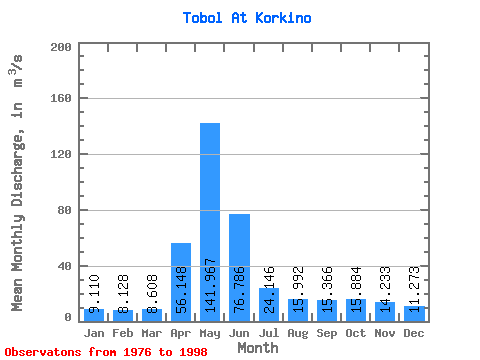
| Statistic | Jan | Feb | Mar | Apr | May | Jun | Jul | Aug | Sep | Oct | Nov | Dec | Annual |
|---|---|---|---|---|---|---|---|---|---|---|---|---|---|
| Mean | 9.11 | 8.13 | 8.61 | 56.15 | 141.97 | 76.79 | 24.15 | 15.99 | 15.37 | 15.88 | 14.23 | 11.27 | 33.83 |
| Standard Deviation | 6.85 | 5.98 | 6.09 | 28.11 | 92.05 | 83.69 | 26.60 | 13.49 | 14.17 | 12.96 | 10.49 | 8.87 | 23.00 |
| Min | 1.65 | 1.86 | 2.46 | 20.40 | 29.00 | 7.70 | 1.84 | 1.95 | 1.90 | 2.87 | 2.57 | 2.24 | 10.23 |
| Max | 32.60 | 27.50 | 29.00 | 117.00 | 375.00 | 281.00 | 107.00 | 61.00 | 66.90 | 58.90 | 46.00 | 36.70 | 97.92 |
| Coefficient of Variation | 0.75 | 0.74 | 0.71 | 0.50 | 0.65 | 1.09 | 1.10 | 0.84 | 0.92 | 0.82 | 0.74 | 0.79 | 0.68 |
 Return to R-Arctic Net Home Page