|
|
|||||||||||||||||
| Point ID: 7242 | Downloads | Plots | Site Data | Code: 12476 |
|
|
|||||||||||||||||
| Download | |
|---|---|
| Site Descriptor Information | Site Time Series Data |
| Link to all available data | |
| View: | Time Series | All |
| Units: | m3/s |
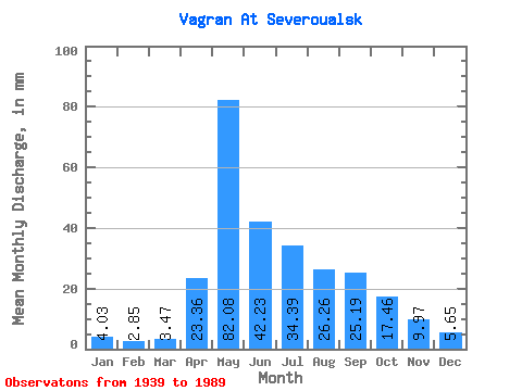
| Statistic | Jan | Feb | Mar | Apr | May | Jun | Jul | Aug | Sep | Oct | Nov | Dec | Annual |
|---|---|---|---|---|---|---|---|---|---|---|---|---|---|
| Mean | 4.03 | 2.87 | 3.47 | 23.36 | 82.06 | 42.23 | 34.38 | 26.25 | 25.19 | 17.46 | 9.97 | 5.65 | 273.38 |
| Standard Deviation | 2.02 | 1.46 | 1.67 | 19.20 | 40.34 | 26.52 | 34.53 | 25.10 | 29.34 | 11.26 | 5.51 | 3.14 | 105.80 |
| Min | 0.81 | 0.34 | 0.28 | 0.71 | 25.65 | 15.94 | 5.70 | 4.22 | 4.09 | 4.26 | 1.64 | 1.30 | 116.05 |
| Max | 9.30 | 6.03 | 6.51 | 92.73 | 194.25 | 139.09 | 203.68 | 108.44 | 166.11 | 50.16 | 28.48 | 16.84 | 594.94 |
| Coefficient of Variation | 0.50 | 0.51 | 0.48 | 0.82 | 0.49 | 0.63 | 1.00 | 0.96 | 1.17 | 0.65 | 0.55 | 0.56 | 0.39 |
 Return to R-Arctic Net Home Page