|
|
|||||||||||||||||
| Point ID: 7242 | Downloads | Plots | Site Data | Code: 12476 |
|
|
|||||||||||||||||
| Download | |
|---|---|
| Site Descriptor Information | Site Time Series Data |
| Link to all available data | |
| View: | Time Series | All |
| Units: | mm |
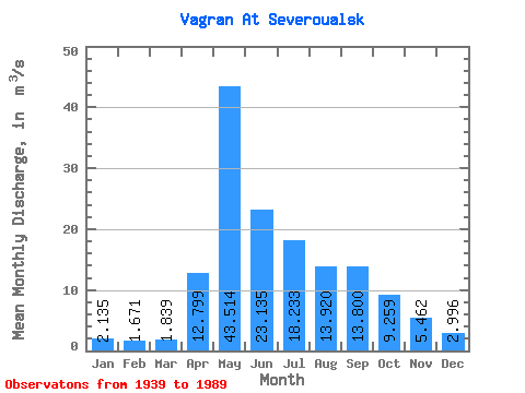
| Statistic | Jan | Feb | Mar | Apr | May | Jun | Jul | Aug | Sep | Oct | Nov | Dec | Annual |
|---|---|---|---|---|---|---|---|---|---|---|---|---|---|
| Mean | 2.13 | 1.67 | 1.84 | 12.80 | 43.51 | 23.14 | 18.23 | 13.92 | 13.80 | 9.26 | 5.46 | 3.00 | 12.30 |
| Standard Deviation | 1.07 | 0.85 | 0.89 | 10.52 | 21.39 | 14.53 | 18.31 | 13.31 | 16.07 | 5.97 | 3.02 | 1.67 | 4.76 |
| Min | 0.43 | 0.20 | 0.15 | 0.39 | 13.60 | 8.73 | 3.02 | 2.24 | 2.24 | 2.26 | 0.90 | 0.69 | 5.22 |
| Max | 4.93 | 3.51 | 3.45 | 50.80 | 103.00 | 76.20 | 108.00 | 57.50 | 91.00 | 26.60 | 15.60 | 8.93 | 26.77 |
| Coefficient of Variation | 0.50 | 0.51 | 0.48 | 0.82 | 0.49 | 0.63 | 1.00 | 0.96 | 1.17 | 0.65 | 0.55 | 0.56 | 0.39 |
 Return to R-Arctic Net Home Page