|
|
|||||||||||||||||
| Point ID: 7220 | Downloads | Plots | Site Data | Code: 12315 |
|
|
|||||||||||||||||
| Download | |
|---|---|
| Site Descriptor Information | Site Time Series Data |
| Link to all available data | |
| View: | Time Series | All |
| Units: | m3/s |
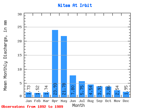
| Statistic | Jan | Feb | Mar | Apr | May | Jun | Jul | Aug | Sep | Oct | Nov | Dec | Annual |
|---|---|---|---|---|---|---|---|---|---|---|---|---|---|
| Mean | 1.73 | 1.53 | 1.74 | 23.93 | 21.78 | 7.80 | 5.75 | 4.54 | 3.91 | 3.86 | 2.54 | 1.95 | 80.80 |
| Standard Deviation | 0.66 | 0.55 | 0.63 | 16.93 | 16.84 | 5.59 | 5.71 | 5.18 | 4.22 | 4.32 | 2.25 | 1.02 | 40.13 |
| Min | 0.39 | 0.48 | 0.63 | 2.32 | 2.34 | 1.23 | 1.23 | 0.90 | 0.81 | 0.96 | 0.70 | 0.68 | 21.04 |
| Max | 3.75 | 2.88 | 3.51 | 73.11 | 81.89 | 29.22 | 32.66 | 31.27 | 25.62 | 25.70 | 16.63 | 6.07 | 191.99 |
| Coefficient of Variation | 0.38 | 0.36 | 0.36 | 0.71 | 0.77 | 0.72 | 0.99 | 1.14 | 1.08 | 1.12 | 0.89 | 0.52 | 0.50 |
 Return to R-Arctic Net Home Page